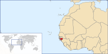
Geography of Guinea-Bissau
Ọdịdị ala nke Guinea-Bissau bụ nke ala dị larịị dị n'ụsọ oké osimiri Atlantic. Mba ahụ gbara Senegal n'ebe ugwu na Guinea n'ebe ndịda ọwụwa anyanwụ.

Ala na gburugburu ebe obibi
dezie
Ala Guinea-Bissau bụ ala dị larịị dị ala n'ụsọ oké osimiri nke nwere ala mmiri nke mangroves nke Guinea na-arịgo na Guinea forest-savanna mosaic n'ebe ọwụwa anyanwụ.[1] Nnyocha nchọpụta zuru ụwa ọnụ na-adịbeghị anya na-atụ aro na e nwere 1,203km2 nke ala mmiri na Guinea-Bissau, na-eme ka ọ bụrụ mba nke iri abụọ na asatọ n'ihe gbasara ebe dị larịị.[2]
Ebe kachasị ala na Guinea-Bissau dị n'elu oké osimiri n'Oké Osimiri Atlantic.[1] Ebe kachasị elu na Guinea-Bissau bụ Monte Torin nke nwere ịdị elu nke 262 m (860 ).[1]
Ihe onwunwe sitere n'okike a chọtara na Guinea-Bissau gụnyere azụ, osisi, phosphates, bauxite, ụrọ, granite, limestone na mmanụ ala a na-ejighị eme ihe. 10.67% nke ala ahụ bụ nke a na-akọ ugbo na 235.6 square kilomita na-agba mmiri.[1][1]
Ihe ize ndụ sitere n'okike gụnyere ọkụ, kpọrọ nkụ, uzuzu harmattan nke nwere ike belata anya n'oge ọkọchị na ọkụ ọkụ.[1] Nsogbu gburugburu ebe obibi siri ike gụnyere mgbukpọ ọhịa; mbuze ala; ịtabiga nri ókè na igbubiga azụ ókè.[1]
N'akụkụ ókèala Senegal, e nweela akụkọ ihe mere eme nke nkịta ịchụ nta, Lycaon pictus, mana enwere ike iwepụ canid ahụ nọ n'ihe ize ndụ ugbu a n'ebe ahụ.
Ọnọdụ ihu igwe
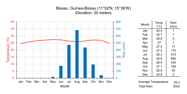
dezieỌnọdụ ihu igwe Guinea-Bissau bụ nke okpomọkụ. Nke a pụtara na ọ na-ekpo ọkụ ma na-ekpuchi. Ọ nwere oge mmiri ozuzo (June ruo November) na ifufe ndịda ọdịda anyanwụ na oge ọkọchị (December ruo May) na ifufe ụgụrụ nke ugwu ọwụwa anyanwụ.[1]
Guinea-Bissau na-ekpo ọkụ n'afọ niile ma enwere obere mgbanwe okpomọkụ; ọ bụ nkezi 26.3 °C (79.3 ). Nkezi mmiri ozuzo maka isi obodo Bissau bụ 2,024 milimita (79.7 in) ọ bụ ezie na nke a fọrọ nke nta ka ọ bụrụ kpamkpam n'oge mmiri ozuzo nke -ada n'etiti June na September / October. Site n'ọnwa Disemba ruo n'ọnwa Eprel, mba ahụ na-enweta obere mmiri ozuzo.
| Climate data for Bissau, Guinea-Bissau (1974-1994) | |||||||||||||
|---|---|---|---|---|---|---|---|---|---|---|---|---|---|
| Month | Jan | Feb | Mar | Apr | May | Jun | Jul | Aug | Sep | Oct | Nov | Dec | Year |
| Record high °C (°F) | 36.7 (98.1) |
38.3 (100.9) |
38.9 (102.0) |
41.1 (106.0) |
39.4 (102.9) |
35.6 (96.1) |
33.3 (91.9) |
32.8 (91.0) |
33.9 (93.0) |
34.4 (93.9) |
35.0 (95.0) |
35.6 (96.1) |
41.1 (106.0) |
| Average high °C (°F) | 31.1 (88.0) |
32.8 (91.0) |
33.9 (93.0) |
33.3 (91.9) |
32.8 (91.0) |
31.1 (88.0) |
29.4 (84.9) |
30.0 (86.0) |
30.0 (86.0) |
31.1 (88.0) |
31.7 (89.1) |
30.6 (87.1) |
31.5 (88.7) |
| Daily mean °C (°F) | 24.4 (75.9) |
25.6 (78.1) |
26.6 (79.9) |
27.0 (80.6) |
27.5 (81.5) |
26.9 (80.4) |
26.1 (79.0) |
26.4 (79.5) |
26.4 (79.5) |
27.0 (80.6) |
26.9 (80.4) |
24.8 (76.6) |
26.3 (79.3) |
| Average low °C (°F) | 17.8 (64.0) |
18.3 (64.9) |
19.4 (66.9) |
20.6 (69.1) |
22.2 (72.0) |
22.8 (73.0) |
22.8 (73.0) |
22.8 (73.0) |
22.8 (73.0) |
22.8 (73.0) |
22.2 (72.0) |
18.9 (66.0) |
21.1 (70.0) |
| Record low °C (°F) | 12.2 (54.0) |
13.3 (55.9) |
15.6 (60.1) |
16.7 (62.1) |
17.2 (63.0) |
19.4 (66.9) |
19.4 (66.9) |
19.4 (66.9) |
19.4 (66.9) |
20.0 (68.0) |
15.0 (59.0) |
12.8 (55.0) |
12.2 (54.0) |
| Average rainfall mm (inches) | 0.5 (0.02) |
0.8 (0.03) |
0.5 (0.02) |
0.8 (0.03) |
17.3 (0.68) |
174.8 (6.88) |
472.5 (18.60) |
682.5 (26.87) |
434.9 (17.12) |
194.8 (7.67) |
41.4 (1.63) |
2.0 (0.08) |
2,022.8 (79.63) |
| Mean monthly sunshine hours | 248 | 226 | 279 | 270 | 248 | 210 | 186 | 155 | 180 | 217 | 240 | 248 | 2,707 |
| Source 1: Sistema de Clasificación Bioclimática Mundial[3] | |||||||||||||
| Source 2: World Climate Guides (sunshine only)[4] | |||||||||||||
nno na mmiri Bissagos
dezie
Ihe ọmụma sitere na CIA World Factbook
dezie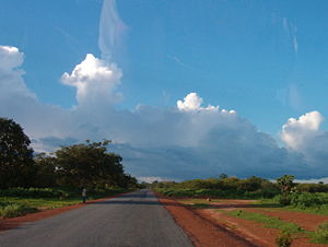


- Location
- Western Africa, bordering the North Atlantic Ocean, between Guinea and Senegal
- Geographic coordinates
- Map references
- Area
-
- Total: 36,125 km2
- Land: 28,120 km2
- Water: 8,005 km2
- Area—comparative
- Slightly less than three times the size of Connecticut
- Land boundaries
- Coastline
- 350 km
- Maritime claims
- Territorial sea
- Lua error in package.lua at line 80: module 'Module:Convert/data' not found.
- Exclusive economic zone: Lua error in package.lua at line 80: module 'Module:Convert/data' not found.
- Terrain
- Mostly low coastal plain rising to savanna in east
- Elevation extremes
-
- Lowest point: Atlantic Ocean 0 m
- Highest point: Unnamed location in the northeast corner of the country 300 m
- Natural resources
- Fish, timber, phosphates, bauxite, unexploited deposits of petroleum
- Land use
-
- Arable land: 10.67%
- Permanent crops: 8.89%
- Other: 80.44% (2012 est.)
- Irrigated land
- 223.6 km2 (2003)
- Total renewable water resources
- 31 km3
- Freshwater withdrawal (domestic/industrial/agricultural)
-
- Total: 0.18 km3/yr (18%/6%/76%)
- Per capita: 135.7 m3/yr (2005)
- Natural hazards
- Hot, dry, dusty harmattan haze may reduce visibility during dry season; brush fires
- Environment—current issues
- Deforestation; soil erosion; overgrazing; overfishing
- Environment—international agreements
-
- Party to: Biodiversity, Climate Change, Desertification, Endangered Species, Hazardous Wastes, Law of the Sea, Ozone Layer Protection, Wetlands
- Signed, but not ratified: None of the selected agreements
Ebe ndị dị oke njọ
dezieNke a bụ ndepụta nke ebe ndị dị oke egwu nke Guinea-Bissau, ebe ndị dị n'ebe ugwu, ndịda, ọwụwa anyanwụ ma ọ bụ ọdịda anyanwụ karịa ebe ọ bụla ọzọ.
- Ebe kachasị n'ebe ugwu bụ akụkụ ugwu nke ókèala ya na Senegal*
- Ebe kachasị n'ebe ọwụwa anyanwụ bụ ebe a na-akpọghị aha n'ókè ya na Guinea ozugbo n'ebe ndịda ọdịda anyanwụ nke obodo Guinean nke Sofan, Gabú Region
- Ebe kachasị n'ebe ndịda bụ isi ala a na-akpọghị aha na Ilha Cataque, Tombali Region
- Ebe ọdịda anyanwụ - Cape Roxo n'ebe ókèala ya na Senegal na-abanye n'Oké Osimiri Atlantic, Cacheu Region
- *Rịba ama: Guinea-Bissau enweghị ebe kachasị n'ebe ugwu, ókèala ebe a bụ nke ahịrị kwụ ọtọ.
Hụkwa
dezieIhe edeturu n'ahịrị
dezie- ↑ 1.0 1.1 1.2 1.3 1.4 1.5 1.6 1.7 U.S. Central Intelligence Agency. World Factbook
- ↑ Murray (2019). "The global distribution and trajectory of tidal flats". Nature 565: 222-225. DOI:10.1038/s41586-018-0805-8.
- ↑ GUINEA-BISSAU - BISSAU. Centro de Investigaciones Fitosociológicas.
- ↑ Bissau Climate Guide. Centro de Investigaciones Fitosociológicas.
Ebensidee
dezie- [Ihe e dere n'ala ala peeji] Nkịta na-achụ nta e sere ese: Lycaon pictus, GlobalTwitcher.com, ed. N. Stromberg
- U.S. Central Intelligence Agency [1]