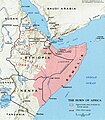
Faịlụ:Somali map.jpg

Otu nyochaa a ha:524 × 600 piksels Ndị ọzọ mkpebi:210 × 240 piksels | 419 × 480 piksels | 671 × 768 piksels | 895 × 1,024 piksels | 1,280 × 1,465 piksels.
Failụ si na nke mbu (1,280 × 1,465 pixel, ívù akwukwo orunótu: 1.92 MB, MIME nke: image/jpeg)
Ịta nke usòrò
Bìri èhì/ogè k'ị hụ òtù ụ̀fa dị̀ m̀gbè ahụ̀.
| Èhì/Ogè | Mbọ-aka | Ógólógó na asaá | Òjìème | Nkwute | |
|---|---|---|---|---|---|
| dị ùgbu â | 20:16, 26 Mee 2024 |  | 1,280 × 1,465 (1.92 MB) | Jacob300 | Reverted to version as of 11:01, 5 February 2024 (UTC) |
| 16:12, 26 Mee 2024 |  | 1,055 × 1,209 (420 KB) | SawsanJojo | Reverted to version as of 15:12, 3 February 2024 (UTC) | |
| 11:01, 5 Febụwarị 2024 |  | 1,280 × 1,465 (1.92 MB) | Jacob300 | Reverted to version as of 18:33, 2 February 2024 (UTC) | |
| 15:12, 3 Febụwarị 2024 |  | 1,055 × 1,209 (420 KB) | Janik98 | Reverted to version as of 13:23, 19 January 2024 (UTC) original CIA map, if you want to add Somaliland just upload a new version of this file | |
| 18:33, 2 Febụwarị 2024 |  | 1,280 × 1,465 (1.92 MB) | Jacob300 | Reverted to version as of 19:30, 12 January 2024 (UTC) | |
| 13:23, 19 Jenụwarị 2024 |  | 1,055 × 1,209 (420 KB) | Janik98 | Reverted to version as of 17:51, 10 January 2024 (UTC) original CIA map, if you want to add Somaliland just upload a new version of this file | |
| 19:30, 12 Jenụwarị 2024 |  | 1,280 × 1,465 (1.92 MB) | Jacob300 | Reverted to version as of 06:59, 10 January 2024 (UTC) | |
| 17:51, 10 Jenụwarị 2024 |  | 1,055 × 1,209 (420 KB) | Janik98 | Reverted to version as of 14:32, 6 January 2024 (UTC) original CIA map, if you want to add Somaliland just upload a new version of this file | |
| 06:59, 10 Jenụwarị 2024 |  | 1,280 × 1,465 (1.92 MB) | Subayerboombastic | Reverted to version as of 21:05, 31 December 2023 (UTC) | |
| 14:32, 6 Jenụwarị 2024 |  | 1,055 × 1,209 (420 KB) | Janik98 | Reverted to version as of 21:00, 29 December 2023 (UTC) original CIA map, if you want to add Somaliland just upload a new version of this file |
Ojiji faịlụ
Ihe ndị na-eso ihe eji Ihu akwụkwọ eme na faịlụ a:
Ejiji failụ zụrụ ọha
Wikis ndi a edeputara na eji kwa failụ a:
- Ihe eji na af.wikipedia.org
- Ihe eji na af.wiktionary.org
- Ihe eji na am.wikipedia.org
- Ihe eji na ar.wikipedia.org
- Ihe eji na arz.wikipedia.org
- Ihe eji na ast.wikipedia.org
- Ihe eji na azb.wikipedia.org
- Ihe eji na az.wikipedia.org
- Ihe eji na be.wikipedia.org
- Ihe eji na bg.wikipedia.org
- Ihe eji na bn.wikipedia.org
- Ihe eji na ca.wikipedia.org
- Ihe eji na ce.wikipedia.org
- Ihe eji na cs.wikipedia.org
- Ihe eji na cy.wikipedia.org
- Ihe eji na da.wikipedia.org
- Ihe eji na de.wikipedia.org
- Ihe eji na en.wikipedia.org
- Ihe eji na en.wikibooks.org
- Ihe eji na eo.wikipedia.org
- Ihe eji na es.wikipedia.org
- Ihe eji na eu.wikipedia.org
Lee more global usage of this file.