Usòrò:Tanezrouft-Reggane(1990).jpg

Otu nyochaa a ha:800 × 451 piksels Ndị ọzọ mkpebi:320 × 180 piksels | 640 × 361 piksels | 1,024 × 577 piksels | 1,280 × 721 piksels | 2,210 × 1,245 piksels.
Failụ si na nke mbu (2,210 × 1,245 pixel, ívù akwukwo orunótu: 612 KB, MIME nke: image/jpeg)
.jpg)
Mmẹkụwátá
| Camera location | | View this and other nearby images on: OpenStreetMap |
|---|
.jpg¶ms=026.622294_N_0000.200859_E_globe:Earth_type:camera__&language=ig)
| Nkówá |
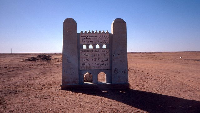
Deutsch: Beginn der Tanezrouft-Piste südlich von Reggane, Algerien
English: Begin of the Tanezrouft road south of Reggane, Algeria |
| Ǹgụ́ụ̀bọ̀chị̀ | Taken on 1 Febụwarị 1990 |
| Mkpọlọ́gwụ̀ | Self-photographed |
| Odé ákwụ́kwọ́ | Albert Backer |
Nkwényé
I, the copyright holder of this work, hereby publish it under the following license:
Edebere faịlụ a n'okpuru ikikeree Creative Commons Attribution-Share Alike 3.0 Unported license.
- I wepulara nóru:
- i nye – ikọpị,ikekasi na izịpụ ọru a
- i dowaria – igbanwee ọrụ a
- Ọ ga bụ na ọnọdụ ndi a:
- í-kpó-áhà – Ị ga-enyerịrị ugo kwesịrị ekwesị, nye njikọ na ikikere ahụ, ma gosikwa ma emere mgbanwe. Ị nwere ike ime ya n'ụzọ ezi uche ọ bụla, mana ọ bụghị n'ụzọ ọ bụla na-egosi na onye nyere ikikere kwadoro gị maọbụ ojiji gị.
- gbásàa kà – Ọ bụrụ na ị tụgharịgharịa, gbanwee, ma ọ bụ wulite n'elu ihe ahụ, ị ga-ekesa ndenye gị n'okpuru otu ma ọ bụ ikike dakọtara dị ka nke mbụ.
|
According to article 50 of the Algerian copyright law, it shall be lawful to reproduce or to communicate to the public, without authorization of the author and without remuneration, a work of architecture or the fine arts, a work of applied arts or a photographic work that is permanently situated in a public place, with the exception of art galleries, museums and classified cultural or natural sites.
See COM:CRT/Algeria#Freedom of panorama for more information.
|
Ịta nke usòrò
Bìri èhì/ogè k'ị hụ òtù ụ̀fa dị̀ m̀gbè ahụ̀.
| Èhì/Ogè | Mbọ-aka | Ógólógó na asaá | Òjìème | Nkwute | |
|---|---|---|---|---|---|
| dị ùgbu â | 21:25, 26 Jenụwarị 2012 | | 2,210 × 1,245 (612 KB) | FatAlbert |
Ojiji faịlụ
Ihe ndị na-eso ihe eji Ihu akwụkwọ eme na faịlụ a:
Ejiji failụ zụrụ ọha
Wikis ndi a edeputara na eji kwa failụ a:
- Ihe eji na arz.wikipedia.org
- Ihe eji na azb.wikipedia.org
- Ihe eji na az.wikipedia.org
- Ihe eji na ceb.wikipedia.org
- Ihe eji na de.wikipedia.org
- Ihe eji na el.wikipedia.org
- Ihe eji na en.wikipedia.org
- Ihe eji na en.wikivoyage.org
- Ihe eji na es.wikipedia.org
- Ihe eji na fa.wikipedia.org
- Ihe eji na fr.wikipedia.org
- Ihe eji na gl.wikipedia.org
- Ihe eji na ha.wikipedia.org
- Ihe eji na hy.wikipedia.org
- Ihe eji na it.wikipedia.org
- Ihe eji na it.wikivoyage.org
- Ihe eji na kab.wikipedia.org
- Ihe eji na lt.wikipedia.org
- Ihe eji na no.wikipedia.org
- Ihe eji na pt.wikipedia.org
- Ihe eji na ro.wikipedia.org
- Ihe eji na sv.wikipedia.org
- Ihe eji na sw.wikipedia.org
- Ihe eji na ts.wikipedia.org
- Ihe eji na tum.wikipedia.org
- Ihe eji na uk.wikipedia.org
- Ihe eji na ur.wikipedia.org
- Ihe eji na vi.wikipedia.org
- Ihe eji na www.wikidata.org
- Ihe eji na yo.wikipedia.org
- Ihe eji na zh.wikipedia.org
- Ihe eji na zh.wikivoyage.org
- Ihe eji na zu.wikipedia.org
.jpg)