Usòrò:MoldRelief.jpg

Otu nyochaa a ha:484 × 599 piksels Ndị ọzọ mkpebi:194 × 240 piksels | 388 × 480 piksels | 620 × 768 piksels | 827 × 1,024 piksels | 1,727 × 2,138 piksels.
Failụ si na nke mbu (1,727 × 2,138 pixel, ívù akwukwo orunótu: 493 KB, MIME nke: image/jpeg)
Mmẹkụwátá
| Nkówá |
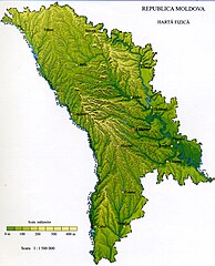
English: Physical map of Moldova
Français : Relief de la République de Moldavie |
|||||
| Ǹgụ́ụ̀bọ̀chị̀ | ||||||
| Mkpọlọ́gwụ̀ | Background: NASA - drawing generated since data from NASA Johnson Space Center - Earth Sciences and Image Analysis (NASA-JSC-ES&IA) ([1] Mission-Roll-Frame ISS001-E-5577, NASA Shuttle Radar Topography Mission (SRTM30) and/or Natural Earth, PD) | |||||
| Odé ákwụ́kwọ́ | Spiridon Manoliu | |||||
| Ọdà (Í jí kwá usòrò nke) |
|

Nkwényé
| I, the copyright holder of this work, release this work into the public domain. This applies worldwide. In some countries this may not be legally possible; if so: I grant anyone the right to use this work for any purpose, without any conditions, unless such conditions are required by law. |
Ịta nke usòrò
Bìri èhì/ogè k'ị hụ òtù ụ̀fa dị̀ m̀gbè ahụ̀.
| Èhì/Ogè | Mbọ-aka | Ógólógó na asaá | Òjìème | Nkwute | |
|---|---|---|---|---|---|
| dị ùgbu â | 19:57, 13 Mee 2009 | | 1,727 × 2,138 (493 KB) | Spiridon Ion Cepleanu | {{Information |Description={{en|1=Physical map of Moldova}} {{fr|1=Relief de la République de Moldavie}} |Source=Spiridon Manoliu's maps |Author=Spiridon Manoliu |Date=13 mai 2009 |Permission= |other_versions= }} <!--{{ImageUpload|full}}--> [[Category:M |
Ojiji faịlụ
Ihe ndị na-eso ihe eji Ihu akwụkwọ eme na faịlụ a:
Ejiji failụ zụrụ ọha
Wikis ndi a edeputara na eji kwa failụ a:
- Ihe eji na arz.wikipedia.org
- Ihe eji na ast.wikipedia.org
- Ihe eji na avk.wikipedia.org
- Ihe eji na az.wikipedia.org
- Ihe eji na bg.wikipedia.org
- Ihe eji na ca.wikipedia.org
- Ihe eji na csb.wikipedia.org
- Ihe eji na de.wikivoyage.org
- Ihe eji na diq.wikipedia.org
- Ihe eji na el.wikipedia.org
- Ihe eji na fi.wiktionary.org
- Ihe eji na fr.wikipedia.org
- Ihe eji na fr.wikinews.org
- Ihe eji na fr.wikivoyage.org
- Ihe eji na ga.wikipedia.org
- Ihe eji na gd.wikipedia.org
- Ihe eji na gl.wikipedia.org
- Ihe eji na ha.wikipedia.org
- Ihe eji na hr.wikipedia.org
- Ihe eji na ht.wikipedia.org
- Ihe eji na ia.wikipedia.org
- Ihe eji na incubator.wikimedia.org
- Ihe eji na ja.wikipedia.org
- Ihe eji na kab.wikipedia.org
- Ihe eji na kcg.wikipedia.org
- Ihe eji na ro.wikipedia.org
- Republica Moldova
- Sauca, Ocnița
- Geografia Republicii Moldova
- Frumușica, Fălești
- Brătușeni, Edineț
- Burlănești, Edineț
- Trinca, Edineț
- Corestăuți, Ocnița
- Maiovca, Ocnița
- Format:Ciot-geo-Republica Moldova
- Afanasievca, Stînga Nistrului
- Albinița, Anenii Noi
- Alexandrovca Nouă, Stînga Nistrului
- Andreevca, Stînga Nistrului
- Andriașevca Nouă, Stînga Nistrului
- Andriașevca Veche, Stînga Nistrului
- Andrușul de Sus, Cahul
- Antonovca, Sîngerei
- Balinții Noi, Soroca
- Balmaz, Anenii Noi
- Baroncea Nouă, Drochia
- Basarabca, Stînga Nistrului
- Batîc, Anenii Noi
- Bîc, Chișinău
- Bobulești, Florești
Lee more global usage of this file.