Usòrò:MIdwest Invasion of 1967 map.svg

Size of this PNG preview of this SVG file: 512 × 291 piksels. Ndị ọzọ mkpebi:320 × 182 piksels | 640 × 364 piksels | 1,024 × 582 piksels | 1,280 × 728 piksels | 2,560 × 1,455 piksels.
Failụ si na nke mbu (usòrò SVG, nà áhà pixel 512 × 291, ívụ usòrò: 34 KB)
Mmẹkụwátá
| Nkówá |
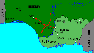
English: Approximate lines of attack used by the Biafran forces during the Midwest Invasion of 1967. The northern pincer is to Auchi and Okene, while the southern pincer is towards Sapele, Warri and Ughelli. |
| Ǹgụ́ụ̀bọ̀chị̀ | |
| Mkpọlọ́gwụ̀ | Orü ọnwé |
| Odé ákwụ́kwọ́ | 141 126 210 103 account |
Nkwényé
I, the copyright holder of this work, hereby publish it under the following license:
This file is licensed under the Creative Commons Attribution-Share Alike 4.0 International license.
- I wepulara nóru:
- i nye – ikọpị,ikekasi na izịpụ ọru a
- i dowaria – igbanwee ọrụ a
- Ọ ga bụ na ọnọdụ ndi a:
- í-kpó-áhà – Ị ga-enyerịrị ugo kwesịrị ekwesị, nye njikọ na ikikere ahụ, ma gosikwa ma emere mgbanwe. Ị nwere ike ime ya n'ụzọ ezi uche ọ bụla, mana ọ bụghị n'ụzọ ọ bụla na-egosi na onye nyere ikikere kwadoro gị maọbụ ojiji gị.
- gbásàa kà – Ọ bụrụ na ị tụgharịgharịa, gbanwee, ma ọ bụ wulite n'elu ihe ahụ, ị ga-ekesa ndenye gị n'okpuru otu ma ọ bụ ikike dakọtara dị ka nke mbụ.
Ịta nke usòrò
Bìri èhì/ogè k'ị hụ òtù ụ̀fa dị̀ m̀gbè ahụ̀.
| Èhì/Ogè | Mbọ-aka | Ógólógó na asaá | Òjìème | Nkwute | |
|---|---|---|---|---|---|
| dị ùgbu â | 20:52, 13 Novemba 2019 | | 512 × 291 (34 KB) | 141 126 210 103 account | User created page with UploadWizard |
Ojiji faịlụ
Ihe ndị na-eso ihe eji Ihu akwụkwọ eme na faịlụ a:
Ejiji failụ zụrụ ọha
Wikis ndi a edeputara na eji kwa failụ a:
- Ihe eji na en.wikipedia.org
- Ihe eji na www.wikidata.org